![]()
Field Sites
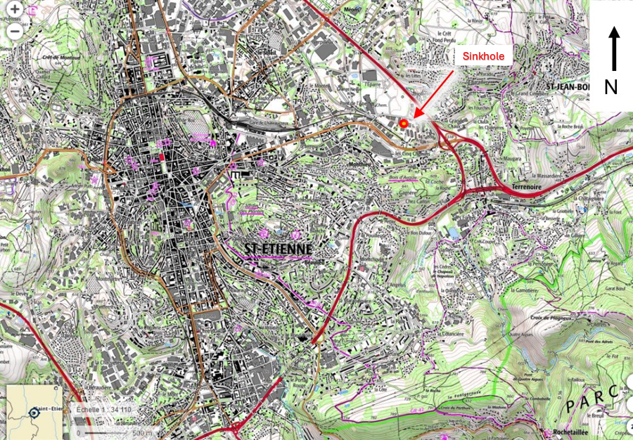
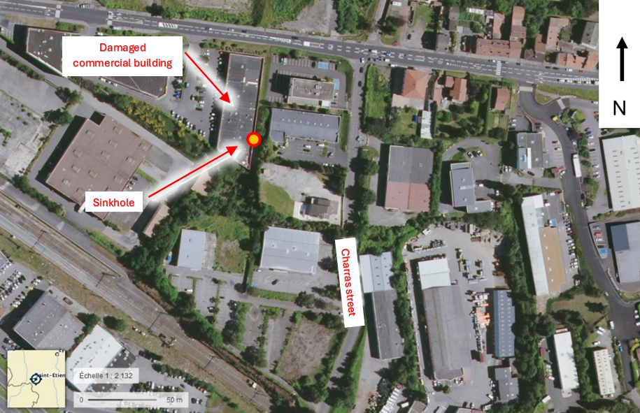
Field Site in France (The Saint-Étienne coal basin)
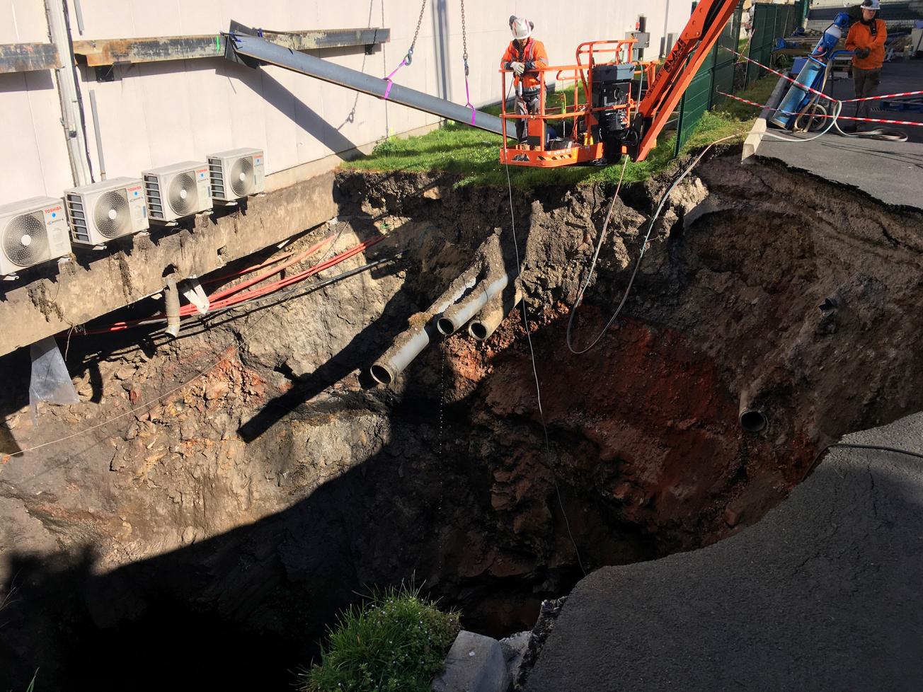
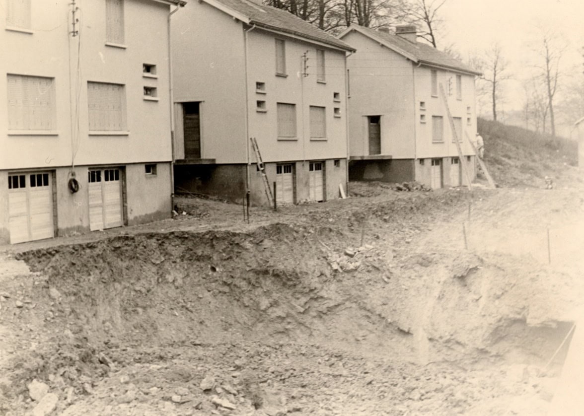
The Saint-Étienne coal basin in the Loire department was the site of extensive industrial coal mining during the 19th and 20th centuries. This activity left numerous underground voids and mining works opening to the surface throughout the urban areas of Saint-Étienne and the Gier Valley. A recent mining-induced sinkhole occurred during the night of March 2 to 3, 2021, beneath a commercial building in Saint-Étienne, within a large commercial activity zone in the Monthieu region. The sinkhole, approximately 10 meters in diameter and 15 meters deep, extends about two meters beneath the commercial building, causing visible surface damage and directly impacting the structure.
The site is well documented and has been linked to former coal mining activity in the area.
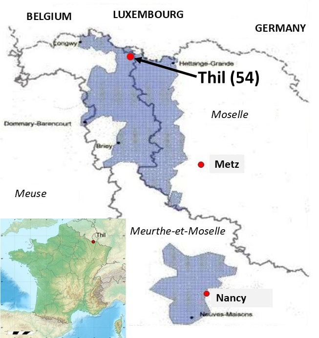
Field Site in France (Thil in the Lorraine iron basin)
The Lorraine iron ore basin is located in the north-east of France and extends from the border with Luxembourg in the north to south of Nancy. It is divided into two sub-basins: the Briey-Longwy basin in the north, and the Nancy basin in the south, covering 1,300 km2 and 380 km2 respectively. The Thil site (in north of Meurthe-et-Moselle) is close to the Luxembourg border (Fig. 1).
Iron formations are found in oolitic sedimentary deposits dating from the Aalenian period (about 150 million years ago). The deposit is alternating mineral-rich seams containing 30-35% iron, separated by less rich areas called interseams. The formation ranges from a few meters to about sixty meters thick. The various seams are found over the entire basin but with variable contents and thicknesses. Depending on the area, one to six seams were exploited in a single vertical operation. The Lorraine deposit lies underneath the Bajocian marl-limestone series. The deposit outcrops in the north, at the borders with Belgium and Luxembourg, and in the east along the Moselle valley. It sinks with an average dip of 3% towards the west to reach a depth of 280 meters at the western limit of the exploitable, managed area.
Ore has been extracted since the middle ages, but industrial mining only began in the 19th century after the Thomas-Gilchrist1 process was invented. Iron ore was first removed manually (extraction and loading). After the Second World War, mechanization developed progressively with use of two main extraction methods: abandoned room and pillar and caving room and pillar Miners could bolt the roof. (see Isabelle Vuidart, Rak Hadadou, Pascale Hanocq, Laurent Semmelbeck. Post-mining management in a major French mining area – example of the Lorraine iron ore basin. Mine Closure 2014 : 9th International Conference on mine closure, Oct 2014, Johannesbourg, South Africa. 14 p. <hal-01100459>). The last working mine in Lorraine closed in 1993.
Historically, France has experienced numerous mining collapses following the flooding of mines, particularly in Eastern part of the country. The first subsidence of this type took place in the South and Center basins, which had been flooded at the beginning of the 1990s. In October 1996, a mining subsidence took place in the town of Coinville, in Auboué (Meurthe-et-Moselle), affecting around eighty houses and making them uninhabitable (sagging roofs, sinkholes in the roads, etc.). In November of the same year, still in Auboué, Metz street, again eighty houses suffered major damage. In May 1997, a subsidence occurred in Moutiers (Meurthe-et-Moselle), during a prefectural visit. In 1998, several other neighbourhoods were affected in Moyeuvre (Moselle), Montois-la-Montagne (Moselle) and Roncourt (Moselle). At the beginning of the 2000s, the number of houses affected in the iron basin was estimated at around five hundred, representing nearly two thousand evacuated residents, mostly expropriated owner-occupiers.
In November 2020, major roof falls were observed at the West sinkhole. Following this observation, the DPSM monitoring frequency was increased (6 months) pending long-term treatment of the area (technico-economic filling study).
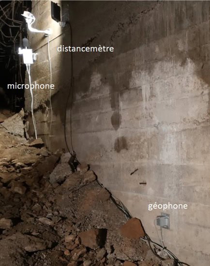
In February 2022, the administration validates the equipment of this cavity with a continuous and multi-technical monitoring system (video sensor, sound level meter, vibration sensor, laser distance measurement). The monitoring system has been operational since March 2023 (Fig. 3). Specific monitoring by the InSAR method of the dynamic and evolving. Thil site will make it possible to analyse possible collapses by benefiting from data acquired from existing instrumental monitoring. Moreover, this relatively shallow former mine working, currently dewatered, constitutes a good opportunity for the observation of ground movement depending on meteoric inputs. It should be noted, that every year, in France, around ten sinkholes are listed per year in all mining basins, including those exploited for coal.
Field Site in Poland (Siersza)
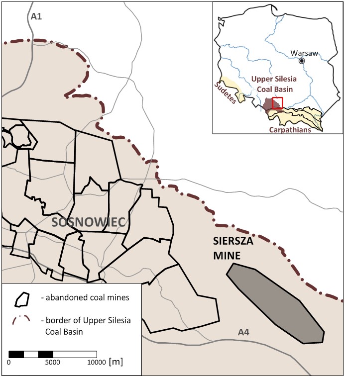
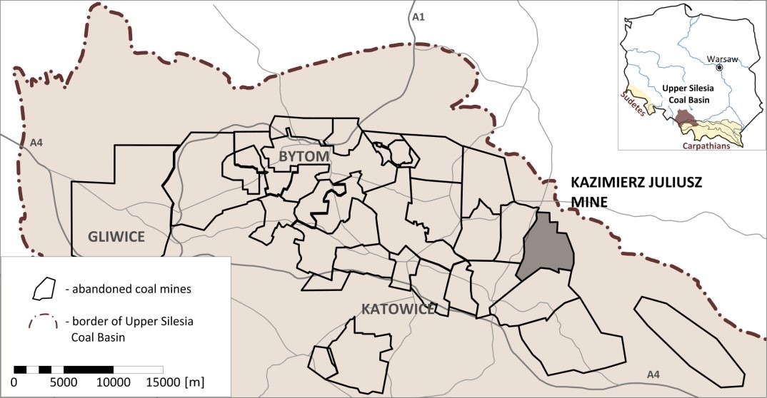
The „Siersza” mine was extracting the “Siersza” hard coal deposit in a mining area of 40,3km2. It was located primarily within the administrative borders of the city of Trzebinia (the Lesser Poland Voivodeship) and partly in Jaworzno (the Upper Silesia Voivodeship) in the north-eastern part of the Upper Silesian Coal Basin (USCB) in Poland. The mine is located on the east border of an area characterised by other coal mines abandoned at the end of the 20th century and the beginning of the 21st century (Fig. 1). The origins of the mine date back to 1861 when the mine was launched under the name “New Izabela”. In 1884 a new shaft “Artur” was launched, from which the mine took its name. In 1947, the “Zbyszek” mine was joined to it under the common name “Siersza”. In 1951 it was connected to the “Krystyna” mine in Tenczyn. On November 1, 1999, the mine liquidation began, and it was finally closed in 2001 (after filling the shafts). In 2000, water pumping was stopped and the process of flooding the mine began.
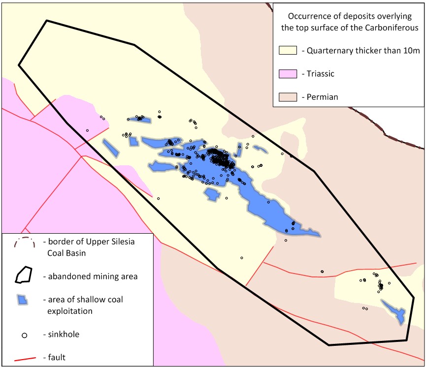
In the central part of the mining area, numerous discontinuous surface deformations related to shallow coal exploitation were observed in the past in the form of sinkholes and funnels caused by the reactivation of old shallow abandoned workings. After 21 years since the cessation of pumping, the problem of post-mining deformations has intensified significantly. This is caused by the rise of the underground water table to the level of the boundary between the Carboniferous and Quaternary formations and the loss of stability of shallow mining excavations.
Field Site in Poland (Kazimierz-Juliusz)
The “Kazimierz-Juliusz” mine was extracting the “Kazimierz-Juliusz I” hard coal deposit in a mining area of 23.08 km2. It was located primarily within the administrative borders of the city of Sosnowiec and partly in Dąbrowa Górnicza and Jaworzno in the northern part of the Upper Silesian Coal Basin in Poland. The mine is located on the southeast border of an area characterised by other coal mines abandoned at the end of the 20th century and the beginning of the 21st century (Fig. 1). Other than the main part of the mining area, the deposits of the Gruszowskie strata were mined over 1880-1944 in the north and the northeast by several mines such as: “Paryż”, “Kazimierz”, “Jakub I”, “Jakub II” and “Dorota”. In May 2015, the coal extraction was concluded, and the flooding of the mine began in October 2016. The mine pit was closed by the end of 2016, while by the end of 2018, the mining plant was completely abandoned.
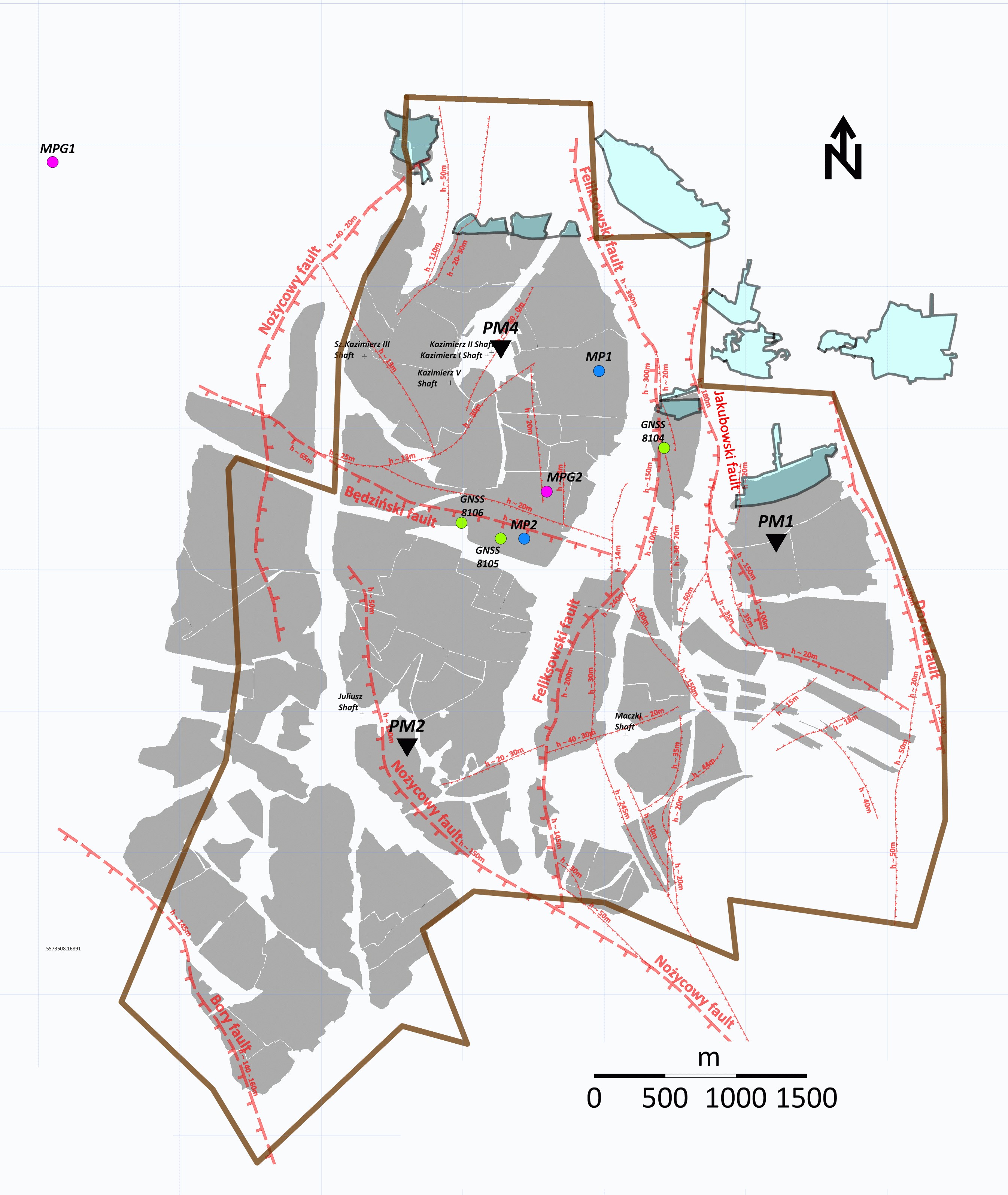
The geological structure of the “Kazimierz-Juliusz” mine consists of Quaternary, Triassic and Carboniferous formations. The Carboniferous strata are deposited below the Quaternary and Triassic sediments (the overburden). The Triassic, carbonate rocks occur only locally in the northern part of the area in question as well as near its southern border. The Carboniferous rock mass at the “Kazimierz-Juliusz” mine is intersected by a dense network of faults with north-south and east-west strikes or similar, formed during the Variscan orogeny.
The hard coal deposit of the “Kazimierz-Juliusz“ mine is located within the following coal-bearing strata: Orzeskie, Rudzkie, Siodłowe, Porębskie, Jaklowieckie and Gruszowskie, and remains largely depleted. In the last phase of mining, the “Kazimierz-Juliusz” mine operated only in seam 510. The 510 seam, 6-22 m thick, was mined nearly throughout the entire area of the mine (Fig. 2). The extraction of seams: 409, 418 and 420 in the Rudzkie strata was concluded in the 1990s, mainly due to the low thickness and quality of the resources, as well as their considerable depletion. In the northern and northeastern parts, the deposits of the Brzeżne strata (seams of group 800: 816, 819, 823, 829 and 833) were mined from their outcrops, already outside the mining lease border (Fig. 2 – cyan colour marks). The thickness of these seams ranged within 1.2 and 2.4 meters.
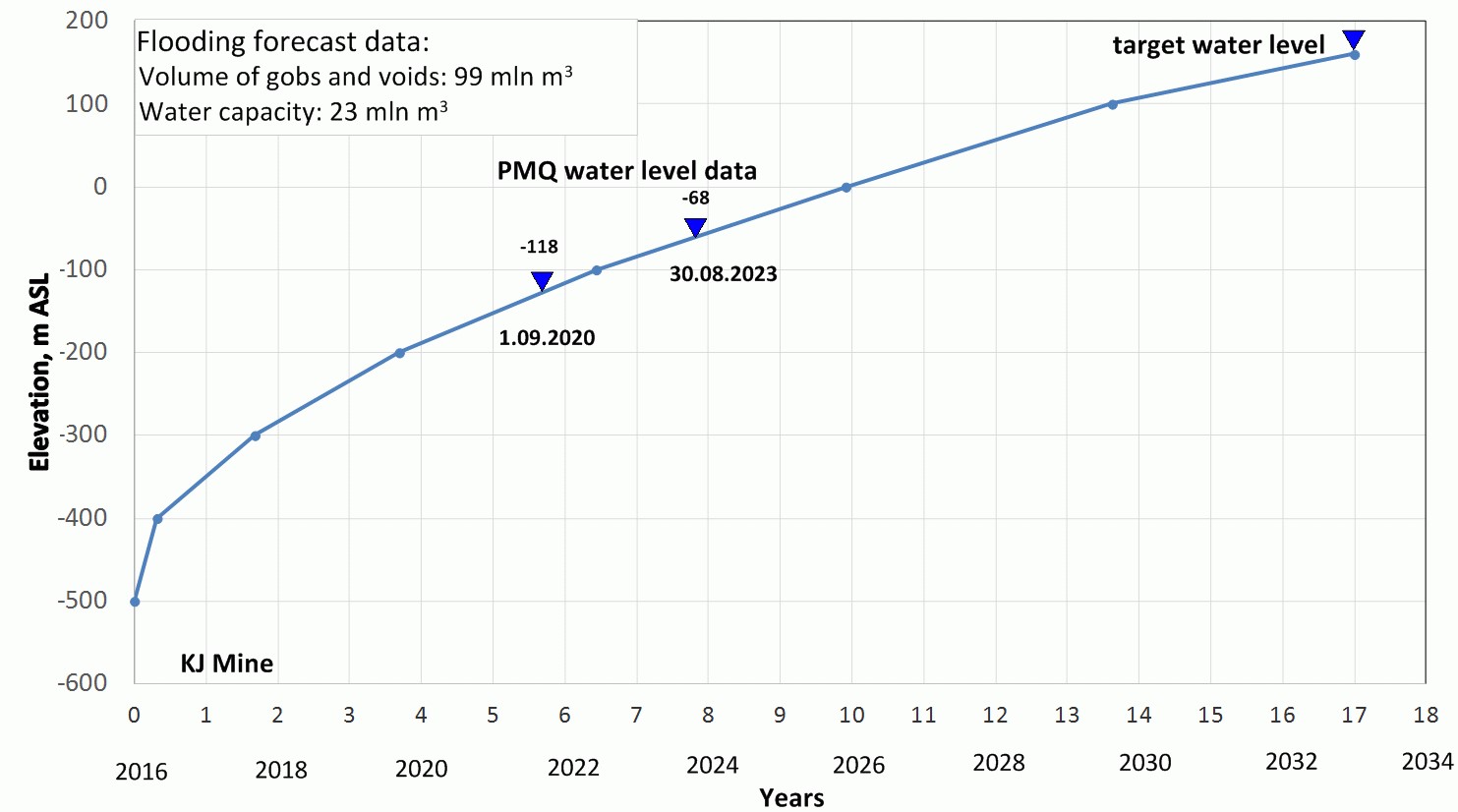
The flooding forecast based on the water level rise in the Carboniferous strata plotted as a function of time before the final closure of the mine is presented in Fig. 3. Groundwater table measurements carried out as part of the PostMinQuake project, corresponding to a period between the 6th and 9th year of flooding, revealed that the groundwater table ranges from -118 to -68 m above sea level. This correlates well with the prepared forecast, according to which the groundwater table should be between -110 m ASL (depth of about 360 m) and -70 m ASL.
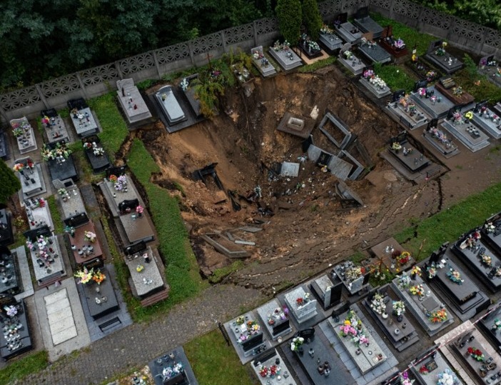
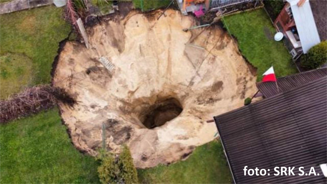
The areas of shallow mining exhibit the highest risk factor for discontinuous ground deformation generation in the form of sinkholes. This is due to the possibility of secondary collapses of post-mining voids left in the rock mass and the flooding of soils in their backfill zones. The impacts of secondary collapses may spread to the surface, resulting in significant environmental damage and affecting the safety of the post-mining areas.
Data presented in this section are fully described in: Kotyrba A., Kortas Ł., Siwek S., 2024 Spatio-Temporal Changes in the Gravity And Post-Mining Seismic Activity in Abandoned Deep Coal Mine Kazimierz-Juliusz During Flooding Journal of Sustainable Mining 23(4):357-372, DOI: 10.46873/2300-3960.1428. For more detailed information about Kazimierz-Juliusz field site please visit PostMinQuake project website (postmiquake.eu).