

Digital Database
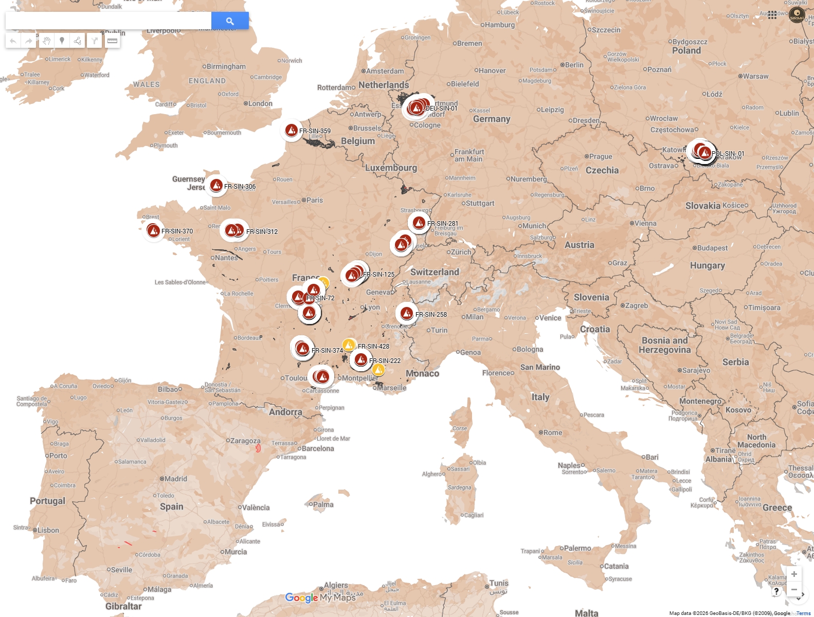
Integrated map of shallow coal mining in Partner’s countries
Disclaimer:
This map is for illustrative purposes only and was developed for informational intents only, as a result of RFCS project No. 101157400 a. SIRIMA. The data presented regarding shallow coal mining areas and the location of sinkholes in Europe does not constitute an official document or geological study within the meaning of applicable law. The information contained on the map may be incomplete or simplified and should not be used for design, investment, or decision-making purposes.
The map or any elements thereof may not be used for commercial purposes, nor may they be copied, distributed, or modified without the prior written consent of the author’s team or the copyright holder.
Sinkholes Database
The sinkhole database provides a basis for analyzing the conditions of the occurrence of the sinkhole to better manage the hazard in the future by the coal region in transition.
The database is structured using an MS Excel format. The structure was finalized and validated by project partners in December 2024. To ensure a comprehensive analysis for future work packages (WP4 and WP5), the database includes a vast array of parameters organized into five main thematic groups:
- Localization (12 data points): This group focuses on the precise identification of the event. It includes unique IDs, names, and various coordinate systems (local X/Y and WGS84). It also records the name of the mine, the country, and the specific municipality where the sinkhole occurred.
- Sinkhole Characteristics (10 data points): This section quantifies the physical disorder. Key fields include the number of sinkholes in a given area, the total impacted surface area (m²), dimensions (length, diameter, width), and the depth of the crater. It also tracks whether the data is an in-situ measurement or an estimation, the date of appearance, and the presumed origin of the collapse (e.g., failure of the roof, pillar, or shaft head).
- Characteristics of Mining Work (12 data points): This theme links surface disorders to underground activities. It records the type of mining work (shaft, cavity, or drift), the start and end dates of exploitation, the dip of the coal seam, and the depth of the workings relative to the surface. It also includes technical details like ground support types and the accessibility of the cavity for inspection.
- Overburden Characteristics (5 data points): These fields describe the geological layers between the mine and the surface. Parameters include the geology of the overburden, the fracture condition of the roof, rock resistance, and water conditions (e.g., dry, seepage, or flooded).
- Surface Consequences: Finally, the database records the presence of buildings or infrastructure in the affected area and any observed damage to human property.
Database fields grouped by theme
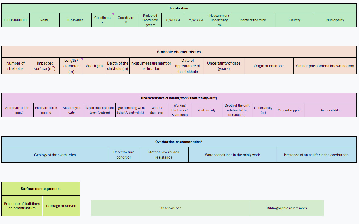
To facilitate data collection, the MS Excel file includes explanatory diagram that visually represent different mining scenarios, such as sub-horizontal drifts, inclined coal seams, and shafts. While the database is deliberately comprehensive to maximize research potential, the sources acknowledge that many fields remain “unknown” due to the historical nature of the data and the loss of archival information over time. Ultimately, this structured approach allows for a multi-scale visualization via the project’s Integrated Map.
InSAR Monitoring
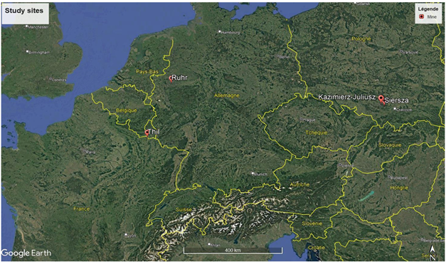
These elements present the InSAR (Interferometric Synthetic Aperture Radar) monitoring results obtained from multiple test sites in France, Poland, and Germany.
Key findings:
• The Thil mine (France) shows mostly stable ground with average velocities between -1 and 1 mm/year, though localized deformation areas were identified within mining risk zones.
• A significant acceleration of ground motion (~5 mm/year) was detected from 2019 onward at a house currently monitored by DPSM in the Thil area.
• The Saint-Étienne site experienced a mining-induced sinkhole in March 2021, with precursory deformation signals detectable in the three months preceding the event.
• Polish and German sites (Siersza, Kazimierz-Juliusz, Ruhr) have experienced significant sinkhole activity in recent years, offering valuable data for precursory signal analysis.
Five mining sites across three countries are being monitored using InSAR techniques:
| Test site | Country | Mine type | Status | Short history |
|---|---|---|---|---|
| Thil | France | Iron ore | Active monitoring since 2020 | Two sinkholes (1956, 1957); roof falls 2018-2020 |
| Saint-Étienne | France | Hard coal | New site (2025) | Sinkhole event March 2021; building affected |
| Siersza (Trzebinia) | Poland | Hard coal | Liquidated 1999 | Groundwater rise; 37+ sinkholes since 2022 |
| Kazimierz-Juliusz | Poland | Hard coal | Closed 2016 | Groundwater rose from -300m to +3.6m in 8 years |
| Ruhr | Germany | Hard coal | Active monitoring | ~2000 sinkholes 1986-2021; urban areas at risk |
All sites are characterized by shallow mining activities and present varying degrees of sinkhole hazard, making them suitable for comparative InSAR analysis.
Two complementary Multi-Temporal InSAR (MT-InSAR) methods were applied:
SBAS (Small Baseline Subset):
SBAS generates spatially continuous deformation fields using networks of interferograms with small spatial and temporal baselines. This method enables reliable time series over broad regions where Persistent Scatterer densities may be limited.
IPTA (Interferometric Point Target Analysis):
IPTA is a Persistent Scatterer technique that identifies phase-stable radar targets (buildings, bare rock) allowing long-term, high-precision deformation monitoring with millimetric accuracy.
Satellite Data:
Sentinel-1 (C-band):
– Open-access data since 2014
– 6-day revisit (both satellites combined), 12-day (single satellite)
– Spatial resolution: 5-20 m (IW mode)
TerraSAR-X (X-band) – requested for higher resolution:
– Spatial resolution: down to 3 m (strip map mode)
– Millimetre precision in interferometric measurements
– Limited temporal coverage compared to Sentinel-1
Thil Mine (France)
Location: Northeastern France (iron-ore deposit)
Monitoring period: November 2015 – April 2025
Track: Sentinel-1 Descending 037
SBAS Results:
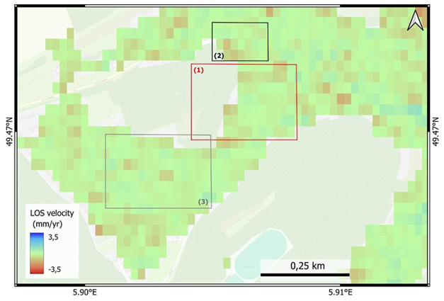
The basin appears mostly stable with average velocities between -1 and 1 mm/year.
Very small subsidence values (motion away from satellite) of around 2-3 mm/year are observed in certain parts of the mined areas.
Local analysis is challenging due to pixel size relative to the scale of mining and risk zones.
IPTA Results:
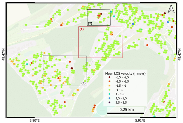
Persistent scatterer analysis confirms the basin is mostly stable (velocities -1 to 1 mm/year). However, localized deformation areas were highlighted at building scale, with accelerated movements within mining areas coinciding with DPSM-identified risk zones.
InSAR studies are ongoing at Polish and German sites led by GIG-PIB and DMT-THGA partners.
Siersza mine (Poland)
Location: Trzebinia
Status: Liquidated in 1999 through shaft filling and cessation of drainage
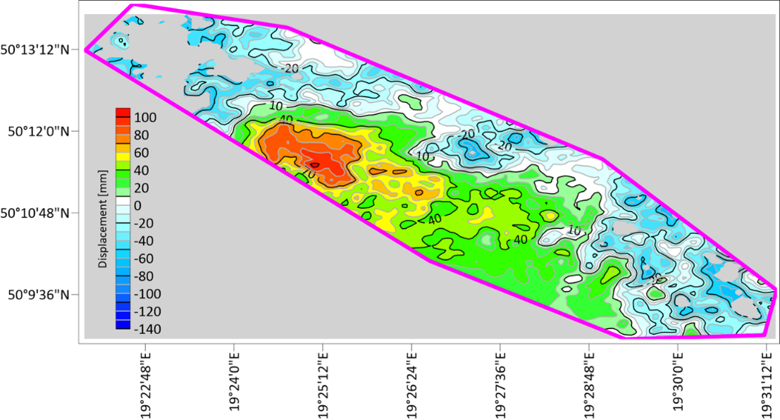
Monitoring: Automatic seismic system, hydrogeological monitoring, regional gravimetry surveys, ground geodetic observations and satellite InSAR
Key concern: Over 37 new sinkholes reported since 2022 as groundwater reached shallowest excavations
Kazimierz-Juliusz Mine (Poland)
Status: Closed in 2016
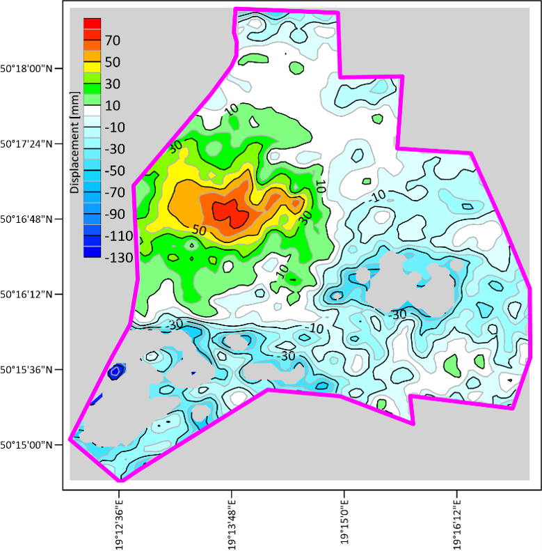
Groundwater rise: from -300 m to approximately +3.6 m above sea level over 8 years
Risk: Uncontrolled sinkhole development (as observed at Siersza)
Monitoring: Groundwater table measurements, gravity measurements, surface geodetic measurements, InSAR
Ruhr Mine (Germany)
Location: North Rhine-Westphalia
Historical context: Mining began in 17th century; southern Ruhr area particularly prone to sinkholes
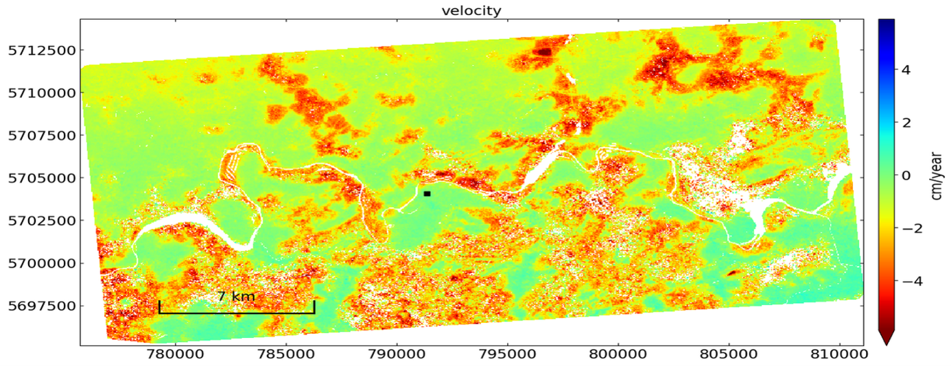
Statistics: Almost 2000 sinkholes occurred between 1986 and 2021
Urban areas at risk: Dortmund, Bochum, Essen, Duisburg
Recent incidents: School and hospital in Bochum affected
InSAR application: Detection of sinkhole precursors and hazard assessment
Gravity Monitoring
Two test sites were selected for performing the monitoring of endangered areas in Poland:
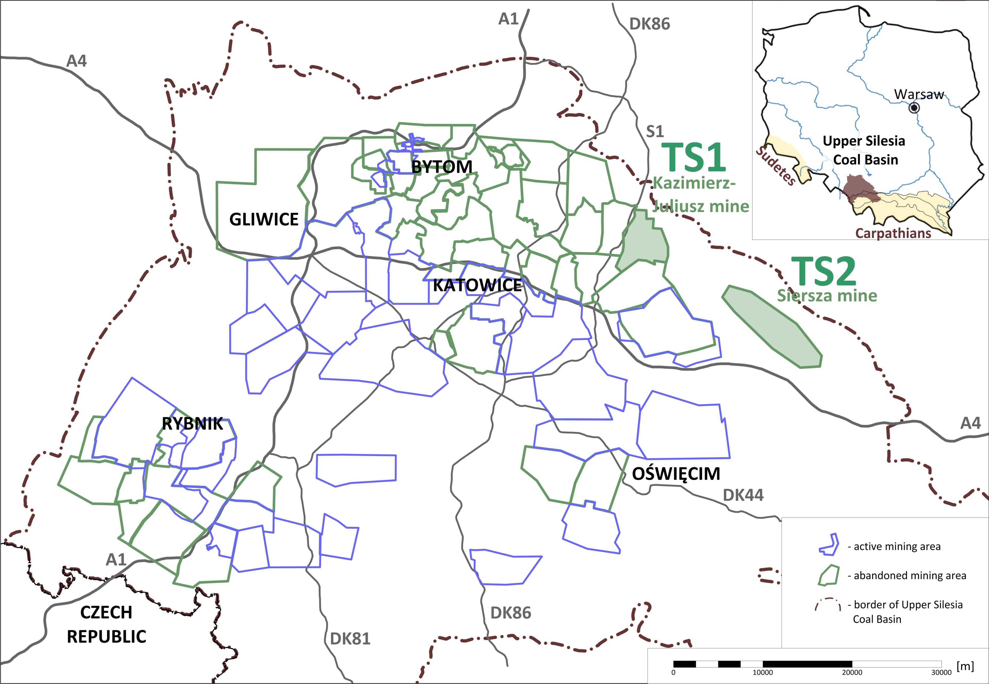
TS1: Kazimierz-Juliusz mine – supplementing the monitoring systems of the POSTMINQUAKE project. The information from field measurements are a continuation with some enhancements of the previous research coexisting with mine flooding process.
TS2: Siersza mine – completely new monitoring elements in the area where the greatest intensity of the formation of new sinkholes is observed since 2022-23.
On both test sites monitoring gear such as piezometers, seismometers and ground monitoring points (geodetic benchmarks) for annual GNSS and gravimetric campaigns was deployed. The collected data will be used for observation of changes in the gravity field in order to obtain additional data about flooding phenomena which in turn will help to assess or predict risk of uncontrolled ground movements.
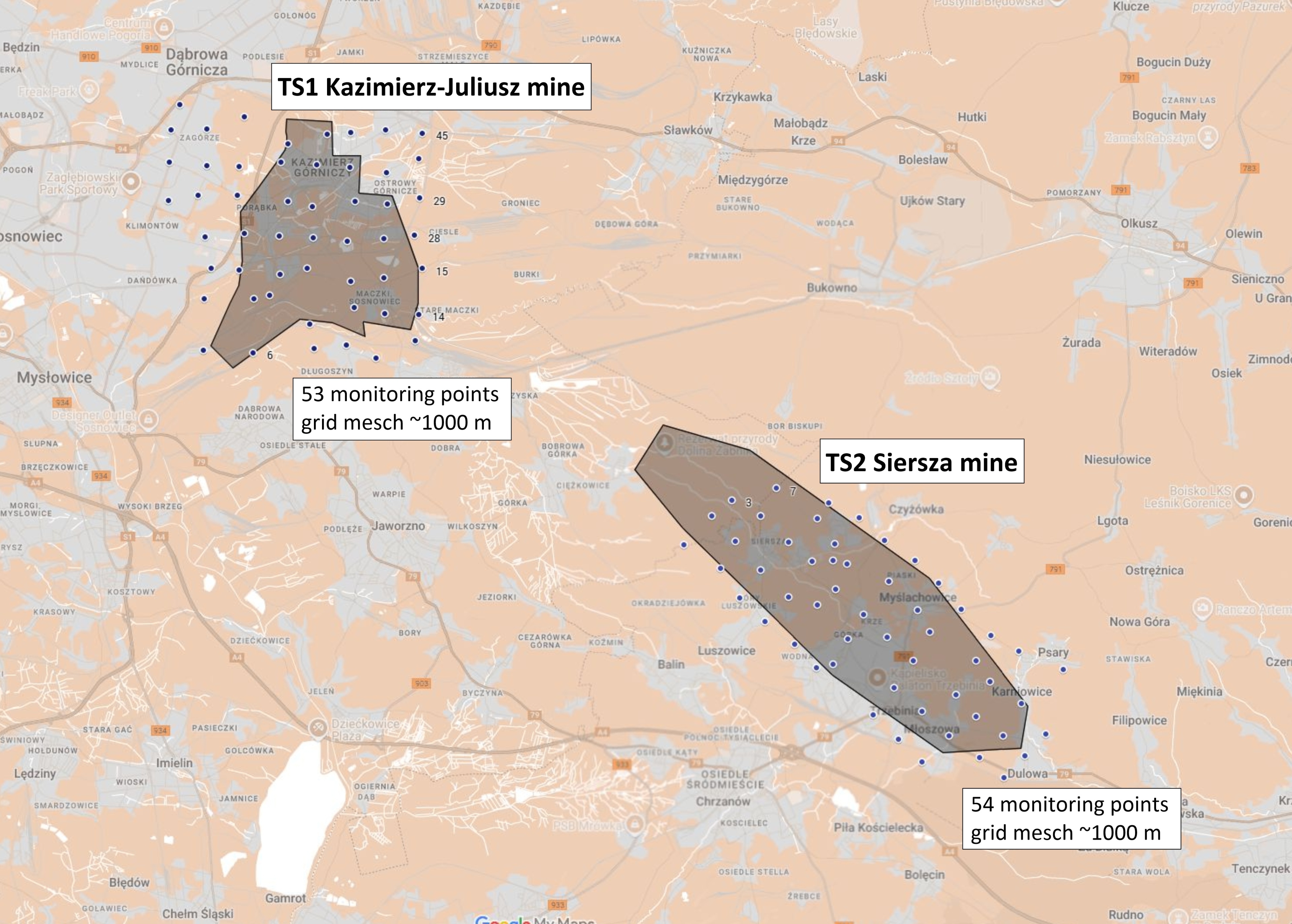
In March, 2025 53 monitoring points in TS1 on Kazimierz-Juliusz mine were renewed and ground stabilisation of the 54 completely new monitoring points on the TS2 was performed.
Stabilization of new points was realized using 60 cm long ground markings with a brass benchmark. In 2025 GNSS measurements were conducted 3 month after the stabilisation. In 2026 the geodetic survey is planned in the second quarter of the year.
Task T2.4 was started with the beginning of the Campaign I with the GNSS measurements in March and along with gravimetric survey lasted till September 2025. As a product of Campaign I the initial data in the form of Hypsometric and Bouguer anomaly distribution maps were obtained.
The next steps within this task will be Campaign II and III in 2026 and 2027. Those upcoming Campaigns will enable the construction of differential maps showing the abnormal variations of Bouguer anomaly distribution within the Test Sites 1 & 2.
Water Level Monitoring
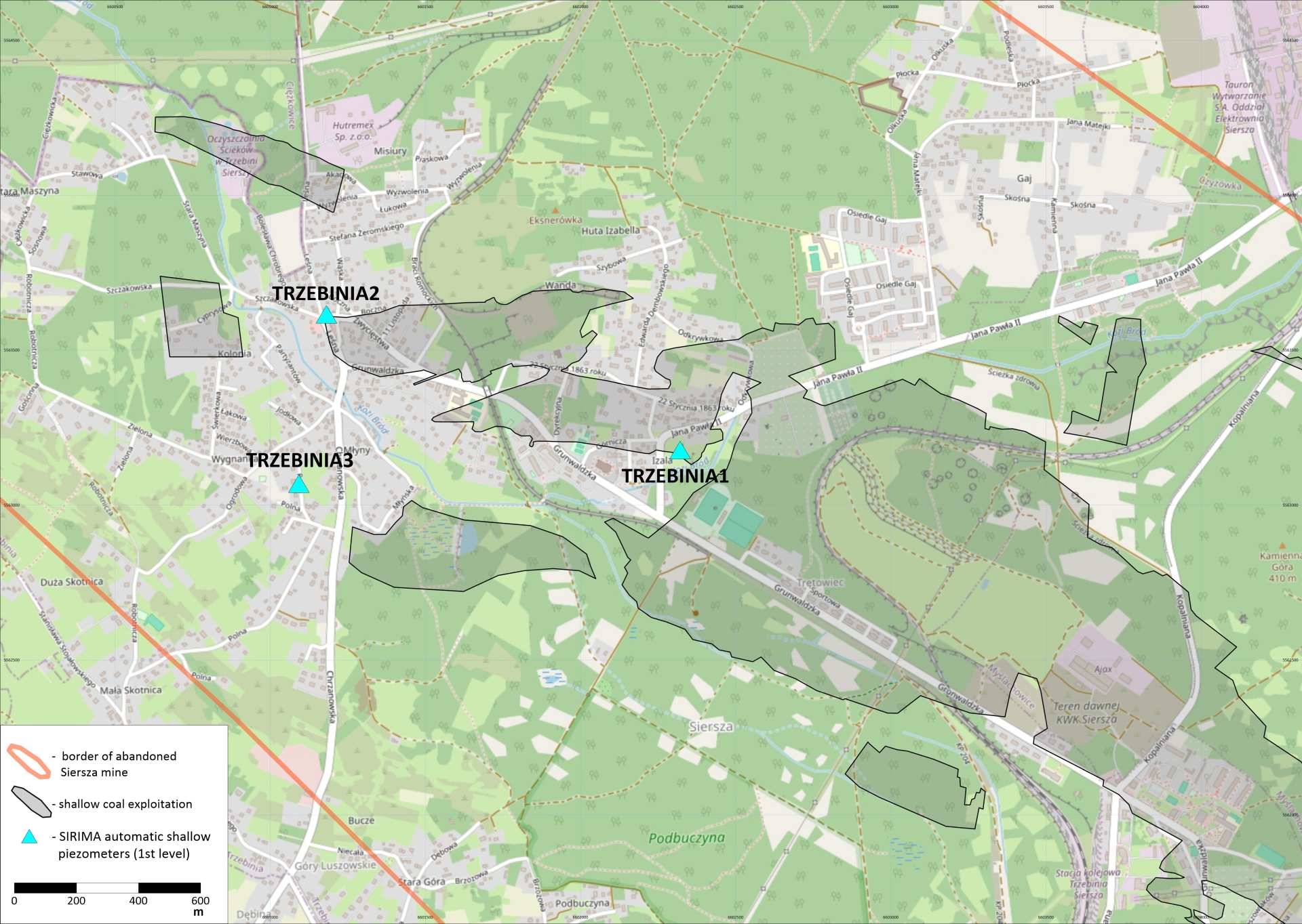
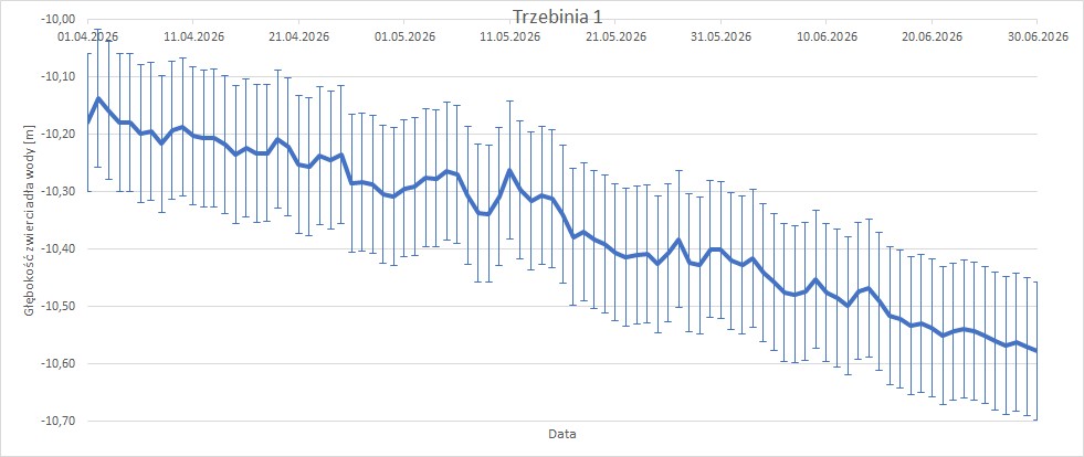
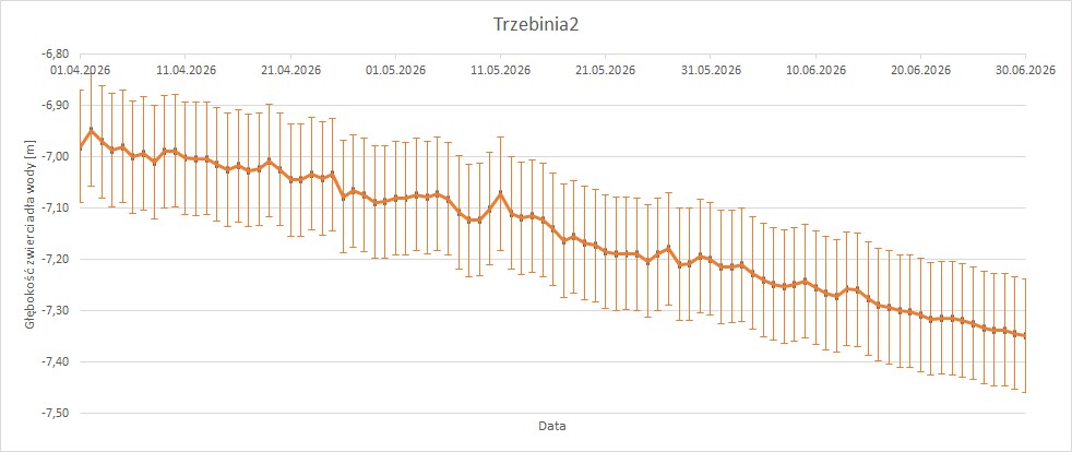
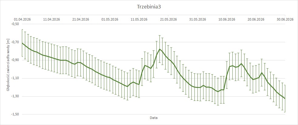
The hydrogeological system on TS2 – Siersza comprises three automated piezometers, named TRZEBINIA1, 2 and 3. The piezometers were installed after a reconnaissance drilling campaign in March 2025 and their purpouse is groundwater level and physicochemical monitoring in the shallow aquifer. These stations are equipped with integrated multiparameter telemetry sensors measuring level, temperature and conductivity, with a sampling capacity ranging from one second to 24 hours. The data is transmitted remotely and powered by photovoltaic panels, ensuring operational autonomy even in low sunlight conditions thanks to backup batteries. Initial analyses indicate that water level variations in the TRZEBINIA1 and 2 piezometers reflect changes in the Quaternary aquifer, which has a strong hydraulic connection with the underlying Carboniferous formations.
Monthly variations of the water level:
AI Modelling
Page under construction